
Palmerton topographic map
Interactive map
Click on the map to display elevation.
Palmerton
The borough is located 3 miles (5 km) east of Bowmanstown and 5 miles (8 km) north of the twin towns of Walnutport and Slatington, 7 miles (11 km) southeast of Lehighton, and 58 miles (93 km) south of the city of Scranton. Palmerton's elevation is 407 feet (124 m) above sea level.
About this map
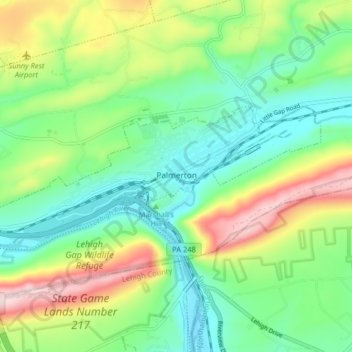
Name: Palmerton topographic map, elevation, terrain.
Location: Palmerton, Carbon County, Pennsylvania, 18071, United States (40.78919 -75.65770 40.81354 -75.57711)
Average elevation: 755 ft
Minimum elevation: 354 ft
Maximum elevation: 1,542 ft
Carbon County trails, hiking, mountain biking, running and outdoor activities
Other topographic maps
Click on a map to view its topography, its elevation and its terrain.
Hickory Run State Park
United States > Pennsylvania > Carbon County > Kidder Township
Average elevation: 1,545 ft
Beltzville State Park - Parking Lot B
United States > Pennsylvania > Carbon County > Lehighton
Average elevation: 728 ft
Albrightsville
United States > Pennsylvania > Carbon County > Kidder Township
Average elevation: 1,634 ft
Albrightsville
United States > Pennsylvania > Carbon County > Kidder Township
Average elevation: 1,634 ft
Lake Harmony
United States > Pennsylvania > Carbon County > Kidder Township > Lake Harmony
Average elevation: 1,808 ft
Germans
United States > Pennsylvania > Carbon County > East Penn Township > Germans
Average elevation: 781 ft