
Condon topographic map
Interactive map
Click on the map to display elevation.
About this map
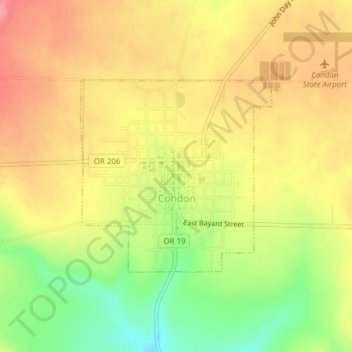
Name: Condon topographic map, elevation, terrain.
Location: Condon, Gilliam County, Oregon, United States (45.22849 -120.19520 45.24326 -120.17435)
Average elevation: 2,858 ft
Minimum elevation: 2,674 ft
Maximum elevation: 2,992 ft
Other topographic maps
Click on a map to view its topography, its elevation and its terrain.
Lonerock
United States > Oregon > Gilliam County
Lonerock, Gilliam County, Oregon, United States
Average elevation: 3,041 ft
Arlington
United States > Oregon > Gilliam County
Arlington, Gilliam County, Oregon, United States
Average elevation: 479 ft