
Thank you for supporting this site ❤️
Make a donation
Make a donation
Gear up for your next adventure:
As an Amazon Associate, this site earns from qualifying purchases at no extra cost to you.
Lonerock topographic map
Click on the map to display elevation.
Thank you for supporting this site ❤️
Make a donation
Make a donation
Gear up for your next adventure:
As an Amazon Associate, this site earns from qualifying purchases at no extra cost to you.
About this map
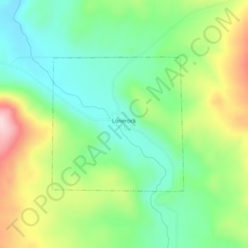
Name: Lonerock topographic map, elevation, terrain.
Location: Lonerock, Gilliam County, Oregon, United States (45.08131 -119.89417 45.09598 -119.87389)
Average elevation: 3,041 ft
Minimum elevation: 2,740 ft
Maximum elevation: 3,573 ft
Gilliam County trails, hiking, mountain biking, running and outdoor activities
Thank you for supporting this site ❤️
Make a donation
Make a donation
Gear up for your next adventure:
As an Amazon Associate, this site earns from qualifying purchases at no extra cost to you.