
Passaic River topographic map
Interactive map
Click on the map to display elevation.
About this map
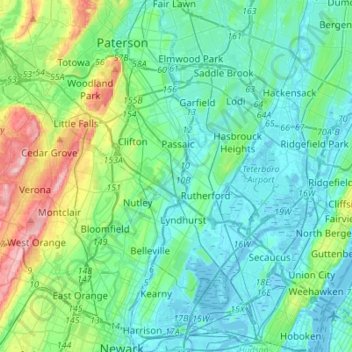
Name: Passaic River topographic map, elevation, terrain.
Average elevation: 138 ft
Minimum elevation: -16 ft
Maximum elevation: 686 ft
Passaic County trails, hiking, mountain biking, running and outdoor activities
Other topographic maps
Click on a map to view its topography, its elevation and its terrain.
Paterson Great Falls National Historical Park
United States > New Jersey > Passaic County > Paterson
Average elevation: 148 ft