
Make a donation
Gear up for your next adventure:
As an Amazon Associate, this site earns from qualifying purchases at no extra cost to you.
Lake Of The Ozarks topographic map
Click on the map to display elevation.
Make a donation
Gear up for your next adventure:
As an Amazon Associate, this site earns from qualifying purchases at no extra cost to you.
Lake Of The Ozarks
The lake was created by the construction of the 2,543-foot (775 m) long Bagnell Dam by the Union Electric Company of St. Louis, Missouri. The principal engineering firm was Stone and Webster. Construction began August 8, 1929, and was completed in April 1931; the lake reached spillway elevation on May 20, 1931.
Make a donation
Gear up for your next adventure:
As an Amazon Associate, this site earns from qualifying purchases at no extra cost to you.
About this map
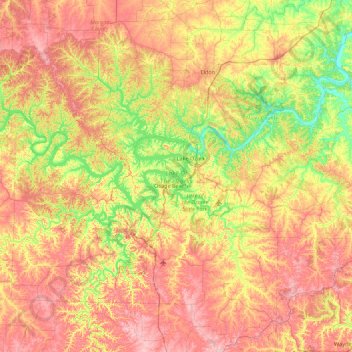
Name: Lake Of The Ozarks topographic map, elevation, terrain.
Average elevation: 869 ft
Minimum elevation: 535 ft
Maximum elevation: 1,250 ft
Camden County trails, hiking, mountain biking, running and outdoor activities
Make a donation
Gear up for your next adventure:
As an Amazon Associate, this site earns from qualifying purchases at no extra cost to you.