Geolocate

Isonville topographic map

Interactive map

Click on the map to display elevation.

About this map

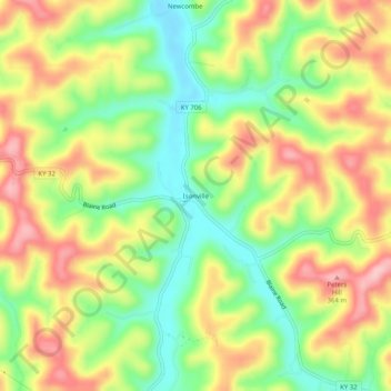
Name: Isonville topographic map, elevation, terrain.

Location: Isonville, Elliott County, Kentucky, 41149, United States (38.04509 -83.07267 38.08509 -83.03267)

Average elevation: 902 ft

Minimum elevation: 650 ft

Maximum elevation: 1,175 ft

Other topographic maps

Click on a map to view its topography, its elevation and its terrain.

Culver

United States > Kentucky > Elliott County

Culver, Elliott County, Kentucky, United States

Average elevation: 889 ft

Stark

United States > Kentucky > Elliott County

Stark, Elliott County, Kentucky, United States

Average elevation: 935 ft

Ibex

United States > Kentucky > Elliott County

Ibex, Elliott County, Kentucky, United States

Average elevation: 817 ft

Newfoundland

United States > Kentucky > Elliott County

Newfoundland, Elliott County, Kentucky, 41171, United States

Average elevation: 850 ft

Sandy Hook

United States > Kentucky > Elliott County

Sandy Hook, Elliott County, Kentucky, United States

Average elevation: 856 ft