Geolocate

Milaca topographic map

Interactive map

Click on the map to display elevation.

About this map

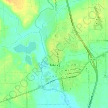
Name: Milaca topographic map, elevation, terrain.

Location: Milaca, Mille Lacs County, Minnesota, United States (45.74225 -93.67812 45.77711 -93.62509)

Average elevation: 1,079 ft

Minimum elevation: 1,033 ft

Maximum elevation: 1,138 ft

Other topographic maps

Click on a map to view its topography, its elevation and its terrain.

Rum River

United States > Minnesota > Mille Lacs County

Rum River, Princeton Township, Mille Lacs County, Minnesota, 55371, United States

Average elevation: 994 ft

Princeton

United States > Minnesota > Mille Lacs County

Princeton, Mille Lacs County, Minnesota, United States

Average elevation: 974 ft

Onamia

United States > Minnesota > Mille Lacs County

Onamia, Mille Lacs County, Minnesota, United States

Average elevation: 1,257 ft

Isle

United States > Minnesota > Mille Lacs County > Isle

Isle, Mille Lacs County, Minnesota, United States

Average elevation: 1,273 ft

Mille Lacs Lake

United States > Minnesota > Mille Lacs County

Mille Lacs Lake, Mille Lacs County, Minnesota, 56432, United States

Average elevation: 1,257 ft