
Honeydew topographic map
Interactive map
Click on the map to display elevation.
About this map
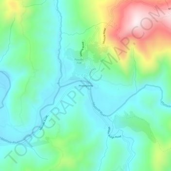
Name: Honeydew topographic map, elevation, terrain.
Average elevation: 830 ft
Minimum elevation: 262 ft
Maximum elevation: 2,356 ft
Humboldt County trails, hiking, mountain biking, running and outdoor activities
Other topographic maps
Click on a map to view its topography, its elevation and its terrain.
Cutten
United States > California > Humboldt County
Cutten, a census-designated place (CDP) in Humboldt County, California, United States, is an unincorporated community, which is part of Greater Eureka. The city was named for David Page Cutten and his family, who were prominent figures in the history of Humboldt County during the early 1850s. Cutten is located…
Average elevation: 144 ft
Blue Lake
United States > California > Humboldt County
Blue Lake (formerly, Scottsville) is a city in Humboldt County, California, United States. Blue Lake is located on the Mad River in a deep valley, 16 miles (26 km) northeast of Eureka, at an elevation of 131 feet (40 m). Its population is 1,208 as of the 2020 census, down from 1,253 from the 2010 census.
Average elevation: 243 ft
Humboldt Hill
United States > California > Humboldt County
Humboldt Hill is a census-designated place (CDP) in Humboldt County, California, United States. Humboldt Hill rises to an elevation of 636 feet (194 m). The population was 3,414 at the 2010 census, up from 3,246 at the 2000 census. The area is in the 95503 zip code and part of unincorporated Eureka.
Average elevation: 148 ft
Hydesville
United States > California > Humboldt County
Hydesville is a census-designated place (CDP) in Humboldt County, California, United States. Hydesville is located 4.5 miles (7.2 km) southeast of Fortuna, at an elevation of 364 feet (111 m). The population was 1,237 at the 2010 census, up from 1,209 at the 2000 census.
Average elevation: 531 ft
South Fork Elk River
United States > California > Humboldt County > Pine Hills
Average elevation: 230 ft
Myrtletown
United States > California > Humboldt County
Myrtletown is a census-designated place (CDP) in Humboldt County, California, United States. Myrtletown lies at an elevation of 112 feet (34 m). Myrtletown is a part of the Eureka, California metropolitan area. The population was 4,675 at the 2010 census, up from 4,459 at the 2000 census.
Average elevation: 69 ft
Harry A. Merlo State Recreational Area
United States > California > Humboldt County > Big Lagoon Rancheria
Average elevation: 108 ft
Rio Dell
United States > California > Humboldt County
Rio Dell (Spanish: Río Dell, meaning "Dell River") is a city in Humboldt County, California, United States. It is located on the west bank of the Eel River 1 mile (2 km) north of Scotia at an elevation of 161 feet (49 m). The population was 3,363 at the 2010 census, up from 3,174 at the 2000 census.
Average elevation: 318 ft
Trinidad
United States > California > Humboldt County
Trinidad (Spanish for "Trinity"; Yurok: Chuerey) is a seaside city in Humboldt County, located on the Pacific Ocean 8 miles (13 km) north of the Arcata-Eureka Airport and 15 miles (24 km) north of the college town of Arcata. Trinidad is noted for its coastline with ten public beaches and offshore rocks, part…
Average elevation: 125 ft
Redwood Forest - Backyards
United States > California > Humboldt County > Eureka
Average elevation: 95 ft
Redway
United States > California > Humboldt County
Redway is a census-designated place (CDP) in Humboldt County, California, United States. Redway is located 2.25 miles (3.6 km) northwest of Garberville, at an elevation of 538 feet (164 m). The population was 1,225 at the 2010 census, up from 1,188 at the 2000 census. Redway is also home to Redway Elementary…
Average elevation: 577 ft