
Otahuhu topographic map
Interactive map
Click on the map to display elevation.
About this map
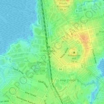
Name: Otahuhu topographic map, elevation, terrain.
Location: Otahuhu, Māngere-Ōtāhuhu, Auckland, New Zealand (-36.94834 174.83468 -36.94826 174.83478)
Average elevation: 39 ft
Minimum elevation: 0 ft
Maximum elevation: 95 ft
Other topographic maps
Click on a map to view its topography, its elevation and its terrain.
Māngere-Ōtāhuhu
New Zealand > Auckland > Māngere-Ōtāhuhu
Māngere-Ōtāhuhu, Auckland, New Zealand
Average elevation: 33 ft