
Hanford topographic map
Interactive map
Click on the map to display elevation.
Hanford
Today's Hanford was once north of Tulare Lake, historically the largest body of fresh water west of the Mississippi River. The area was inhabited by the Tachi Yokut Indians for several thousand years prior to Euro-American contact. They occupied locations along watercourses such as creeks, springs and seep areas (such as sloughs), along perennial and seasonal drainages, as well as flat ridges and terraces. Therefore, places along streams are considered likely locations for prehistoric cultural resources. Permanent villages were usually placed on an elevation above the seasonal flood levels. Surrounding areas were used for hunting and seed, acorn, and grass gathering.
About this map
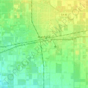
Name: Hanford topographic map, elevation, terrain.
Location: Hanford, Kings County, California, 93230, United States (36.26592 -119.69103 36.37189 -119.60082)
Average elevation: 240 ft
Minimum elevation: 213 ft
Maximum elevation: 269 ft
Kings County trails, hiking, mountain biking, running and outdoor activities
Other topographic maps
Click on a map to view its topography, its elevation and its terrain.
Armona
United States > California > Kings County > Armona
Armona is a census-designated place (CDP) in Kings County, California, United States. Armona is located 3.5 miles (5.6 km) west-southwest of Hanford, at an elevation of 239 feet (73 m). It is part of the Hanford–Corcoran Metropolitan Statistical Area. The population was 4,156 at the 2010 census. Armona's…
Average elevation: 230 ft