
Les Guibertes topographic map
Click on the map to display elevation.
About this map
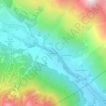
Name: Les Guibertes topographic map, elevation, terrain.
Average elevation: 5,741 ft
Minimum elevation: 4,544 ft
Maximum elevation: 8,438 ft
Other topographic maps
Click on a map to view its topography, its elevation and its terrain.
Glacier du Réou d'Arsine
France > Provence-Alpes-Côte d'Azur > Hautes-Alpes > Le Monêtier-les-Bains
Average elevation: 9,206 ft
05220
France > Provence-Alpes-Côte d'Azur > Hautes-Alpes > Le Monêtier-les-Bains
Average elevation: 6,060 ft
Glacier Supérieur d'Arsine
France > Provence-Alpes-Côte d'Azur > Hautes-Alpes > Le Monêtier-les-Bains
Average elevation: 9,728 ft