
Alsea topographic map
Click on the map to display elevation.
About this map
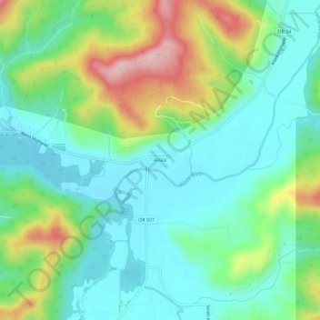
Name: Alsea topographic map, elevation, terrain.
Location: Alsea, Benton County, Oregon, United States (44.36151 -123.61649 44.40151 -123.57649)
Average elevation: 505 ft
Minimum elevation: 243 ft
Maximum elevation: 1,125 ft
Benton County trails, hiking, mountain biking, running and outdoor activities
Other topographic maps
Click on a map to view its topography, its elevation and its terrain.
Corvallis
United States > Oregon > Benton County
Corvallis is at an elevation of 235 feet (72 m) above sea level. Situated midway in the Willamette Valley, in terms of driving distances, Corvallis is about 46 miles (74 km) east of Newport and the Oregon Coast, 85 miles (137 km) south of Portland, 30 miles (48 km) south of the state capital, Salem, 10 miles…
Average elevation: 266 ft