
Sugar Hill topographic map
Interactive map
Click on the map to display elevation.
Sugar Hill
According to the United States Census Bureau, as of 2010 the city of Sugar Hill had a total land area of 10.6 square miles (27.5 km2), of which 0.04 square miles (0.1 km2), or 0.33%, was water. The U.S. Geological Survey lists the city's elevation as 1,149 feet (350 m).
About this map
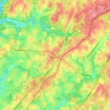
Name: Sugar Hill topographic map, elevation, terrain.
Location: Sugar Hill, Gwinnett County, Georgia, United States (34.06466 -84.10169 34.15187 -84.01418)
Average elevation: 1,089 ft
Minimum elevation: 909 ft
Maximum elevation: 1,257 ft
Gwinnett County trails, hiking, mountain biking, running and outdoor activities
Other topographic maps
Click on a map to view its topography, its elevation and its terrain.
Settles Bridge
United States > Georgia > Gwinnett County > Suwanee > Settles Bridge
Average elevation: 1,030 ft
Rock Creek Estates
United States > Georgia > Gwinnett County > Buford > Rock Creek Estates
Average elevation: 1,109 ft