
Lafayette Square topographic map
Interactive map
Click on the map to display elevation.
About this map
Name: Lafayette Square topographic map, elevation, terrain.
Average elevation: 16 ft
Minimum elevation: -16 ft
Maximum elevation: 105 ft
Orleans Parish trails, hiking, mountain biking, running and outdoor activities
Other topographic maps
Click on a map to view its topography, its elevation and its terrain.
Lakeview
United States > Louisiana > Orleans Parish > New Orleans
Lakeview is located at 30°00′24″N 90°06′28″W / 30.00667°N 90.10778°W / 30.00667; -90.10778 and has an elevation of 0 feet (0.0 m). According to the United States Census Bureau, the district has a total area of 1.61 square miles (4.2 km2). 1.61 square miles (4.2 km2) of which is land and…
Average elevation: 7 ft
Algiers Point
United States > Louisiana > Orleans Parish > New Orleans > Algiers
Average elevation: 10 ft
Lower Ninth Ward
United States > Louisiana > Orleans Parish > New Orleans
The most severely damaged section of the Ward was the lower elevation section, north of Claiborne Avenue. A Bring Back New Orleans Commission preliminary report suggested making this area in whole or part into park space because of the high risk of future flooding. Most Lower 9th Ward residents have strongly…
Average elevation: 3 ft
Lower Garden District
United States > Louisiana > Orleans Parish > New Orleans > Lower Garden District
Lower Garden District is located at 29°56′02″N 90°04′12″W / 29.93389°N 90.07000°W / 29.93389; -90.07000 and has an elevation of 6 feet (1.8 m). According to the United States Census Bureau, the district has a total area of 1.16 square miles (3.0 km2), 0.95 square miles (2.5 km2) of which…
Average elevation: 10 ft
Audubon Park
United States > Louisiana > Orleans Parish > New Orleans > Greenville
Average elevation: 13 ft
Broadmoor
United States > Louisiana > Orleans Parish > New Orleans > Broadmoor
Broadmoor is located at 29°56′56″N 90°06′15″W / 29.94889°N 90.10417°W / 29.94889; -90.10417 and has an elevation of 2 feet (0.6 m). According to the United States Census Bureau, the district has a total area of 0.56 square miles (1.5 km2). 0.56 square miles (1.5 km2) of which is land and…
Average elevation: 7 ft
Hollygrove
United States > Louisiana > Orleans Parish > New Orleans > Hollygrove
Average elevation: 7 ft
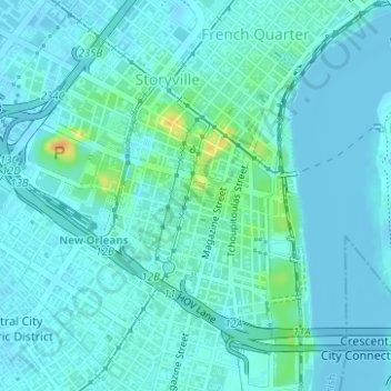
Storyville
United States > Louisiana > Orleans Parish > New Orleans > Storyville
Average elevation: 10 ft