
Benton topographic map
Interactive map
Click on the map to display elevation.
About this map
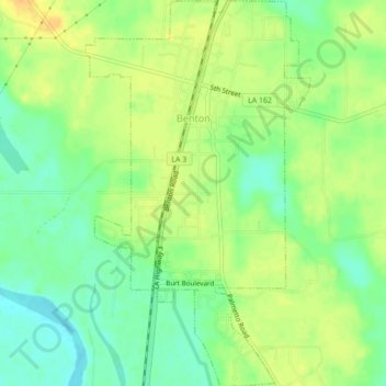
Name: Benton topographic map, elevation, terrain.
Location: Benton, Bossier Parish, Louisiana, United States (32.66945 -93.75400 32.70599 -93.72862)
Average elevation: 203 ft
Minimum elevation: 151 ft
Maximum elevation: 253 ft
Bossier Parish trails, hiking, mountain biking, running and outdoor activities
Other topographic maps
Click on a map to view its topography, its elevation and its terrain.
Bossier City
United States > Louisiana > Bossier Parish
Bossier City is located at 32°31′4″N 93°41′29″W / 32.51778°N 93.69139°W / 32.51778; -93.69139 (32.517651, −93.691397) within the Ark-La-Tex and has an elevation of 174 feet (53.0 m) above sea level. The city lies primarily on the banks of the Red River, and has a largely flat topography…
Average elevation: 180 ft