
Make a donation
Gear up for your next adventure:
As an Amazon Associate, this site earns from qualifying purchases at no extra cost to you.
Rockport topographic map
Click on the map to display elevation.
Make a donation
Gear up for your next adventure:
As an Amazon Associate, this site earns from qualifying purchases at no extra cost to you.
Rockport
The topography of Rockport, Texas, is defined by its flat, coastal terrain, with the city's average elevation being around 20 feet above sea level. The land is largely shaped by the proximity to the Gulf of Mexico, which influences the area's low-lying nature, including some areas below sea level. The surrounding region is characterized by shallow waters, estuaries, and salt marshes, providing rich wildlife habitats. This coastal setting contributes to Rockport's scenic beaches and its status as a popular tourist destination, offering views of the water and nearby islands.
Make a donation
Gear up for your next adventure:
As an Amazon Associate, this site earns from qualifying purchases at no extra cost to you.
About this map
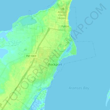
Name: Rockport topographic map, elevation, terrain.
Location: Rockport, Aransas County, Texas, 78382, United States (27.96631 -97.11330 28.09711 -96.99953)
Average elevation: 10 ft
Minimum elevation: -7 ft
Maximum elevation: 46 ft
Aransas County trails, hiking, mountain biking, running and outdoor activities
Make a donation
Gear up for your next adventure:
As an Amazon Associate, this site earns from qualifying purchases at no extra cost to you.
Other topographic maps
Click on a map to view its topography, its elevation and its terrain.