
Big Bear Lake topographic map
Interactive map
Click on the map to display elevation.
Big Bear Lake
At a surface elevation of 6,743 ft (2,055 m) above sea level, it has an east-west length of approximately seven miles (11 km) and is approximately 2.5 miles (4.0 km) at its widest measurement, though the lake's width mostly averages a little more than 1⁄2 mi (0.8 km). These approximations are based on the lake having an optimum retainable water level. At dam's end, Big Bear measures its deepest water at 72 feet (22 m).
About this map
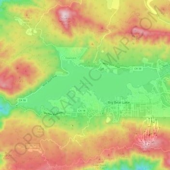
Name: Big Bear Lake topographic map, elevation, terrain.
Average elevation: 7,247 ft
Minimum elevation: 6,250 ft
Maximum elevation: 8,346 ft
San Bernardino County trails, hiking, mountain biking, running and outdoor activities