
Waxahachie topographic map
Interactive map
Click on the map to display elevation.
About this map
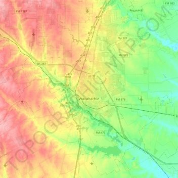
Name: Waxahachie topographic map, elevation, terrain.
Location: Waxahachie, Ellis County, Texas, United States (32.31442 -96.96361 32.49495 -96.74421)
Average elevation: 607 ft
Minimum elevation: 440 ft
Maximum elevation: 781 ft
Ellis County trails, hiking, mountain biking, running and outdoor activities
Other topographic maps
Click on a map to view its topography, its elevation and its terrain.