
Abidjan topographic map
Interactive map
Click on the map to display elevation.
About this map
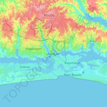
Name: Abidjan topographic map, elevation, terrain.
Location: Abidjan, Le Plateau, Abidjan, Côte d'Ivoire (5.16036 -4.17611 5.48036 -3.85611)
Average elevation: 105 ft
Minimum elevation: -16 ft
Maximum elevation: 443 ft
Other topographic maps
Click on a map to view its topography, its elevation and its terrain.
Port-Bouët
Côte d'Ivoire > Abidjan > Port-Bouët
Port-Bouët, Abidjan, 12, Côte d'Ivoire
Average elevation: 39 ft