
East Windsor Township topographic map
Interactive map
Click on the map to display elevation.
About this map
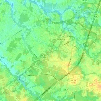
Name: East Windsor Township topographic map, elevation, terrain.
Average elevation: 108 ft
Minimum elevation: 66 ft
Maximum elevation: 167 ft
Mercer County trails, hiking, mountain biking, running and outdoor activities
Other topographic maps
Click on a map to view its topography, its elevation and its terrain.
Hillside Terrace
United States > New Jersey > Mercer County > Robbinsville Township
Average elevation: 115 ft
Robbinsville
United States > New Jersey > Mercer County > Robbinsville Township
Average elevation: 105 ft
Coopers Corner
United States > New Jersey > Mercer County > Hopewell Township
Average elevation: 341 ft
Hamilton Square
United States > New Jersey > Mercer County > Hamilton Township
Average elevation: 95 ft