
Make a donation
Gear up for your next adventure:
As an Amazon Associate, this site earns from qualifying purchases at no extra cost to you.
Readyville topographic map
Click on the map to display elevation.
Make a donation
Gear up for your next adventure:
As an Amazon Associate, this site earns from qualifying purchases at no extra cost to you.
About this map
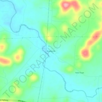
Name: Readyville topographic map, elevation, terrain.
Average elevation: 696 ft
Minimum elevation: 587 ft
Maximum elevation: 1,004 ft
Cannon County trails, hiking, mountain biking, running and outdoor activities
Make a donation
Gear up for your next adventure:
As an Amazon Associate, this site earns from qualifying purchases at no extra cost to you.
Other topographic maps
Click on a map to view its topography, its elevation and its terrain.
Woodbury
United States > Tennessee > Cannon County
The climate of Woodbury is a wet subtropical (Köppen Cfa) one with mild winters and hot summers. The diurnal temperature variation is unusual for such a rainy low-altitude climate, which leads to it having record highs and lows extreme for Tennessee; the temperature amplitude is 138 °F. Under the Trewartha…
Average elevation: 791 ft