
Belleville topographic map
Interactive map
Click on the map to display elevation.
About this map
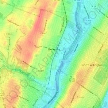
Name: Belleville topographic map, elevation, terrain.
Location: Belleville, Essex County, New Jersey, 07109, United States (40.77456 -74.18676 40.80962 -74.13845)
Average elevation: 92 ft
Minimum elevation: -10 ft
Maximum elevation: 187 ft
Essex County trails, hiking, mountain biking, running and outdoor activities
Other topographic maps
Click on a map to view its topography, its elevation and its terrain.
Saint Cloud
United States > New Jersey > Essex County > West Orange > Saint Cloud
Average elevation: 463 ft