Geolocate

Hayward topographic map

Interactive map

Click on the map to display elevation.

About this map

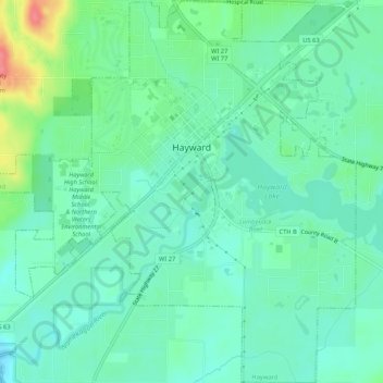
Name: Hayward topographic map, elevation, terrain.

Location: Hayward, Sawyer County, Wisconsin, United States (45.99032 -91.51435 46.02703 -91.46219)

Average elevation: 1,204 ft

Minimum elevation: 1,142 ft

Maximum elevation: 1,371 ft

Other topographic maps

Click on a map to view its topography, its elevation and its terrain.

Little Round Lake

United States > Wisconsin > Sawyer County

Little Round Lake, Town of Bass Lake, Sawyer County, Wisconsin, United States

Average elevation: 1,348 ft

Winter

United States > Wisconsin > Sawyer County

Winter, Sawyer County, Wisconsin, United States

Average elevation: 1,355 ft

Seeley

United States > Wisconsin > Sawyer County

Seeley, Town of Lenroot, Sawyer County, Wisconsin, United States

Average elevation: 1,309 ft

Exeland

United States > Wisconsin > Sawyer County > Exeland

Exeland, Sawyer County, Wisconsin, United States

Average elevation: 1,207 ft