
Laurel Knob topographic map
Interactive map
Click on the map to display elevation.
About this map
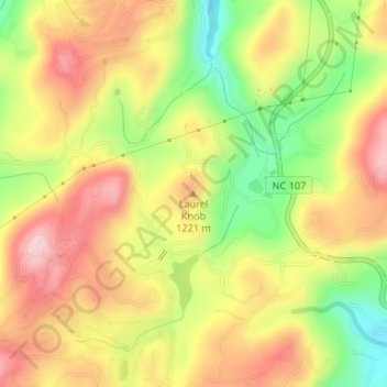
Name: Laurel Knob topographic map, elevation, terrain.
Average elevation: 3,855 ft
Minimum elevation: 3,481 ft
Maximum elevation: 4,163 ft
Jackson County trails, hiking, mountain biking, running and outdoor activities
Other topographic maps
Click on a map to view its topography, its elevation and its terrain.
Panthertown Valley Backcountry Area
United States > North Carolina > Jackson County
Average elevation: 3,671 ft
Bear Creek Lake
United States > North Carolina > Jackson County > Island Ford
Average elevation: 3,071 ft
Wolftown Community
United States > North Carolina > Jackson County > Wolftown Community
Average elevation: 3,665 ft