
National Park topographic map
Interactive map
Click on the map to display elevation.
About this map
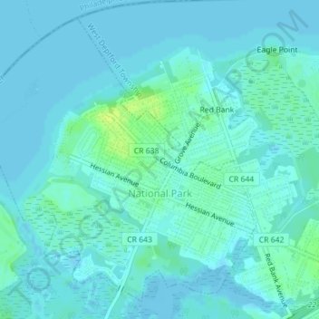
Name: National Park topographic map, elevation, terrain.
Average elevation: 10 ft
Minimum elevation: -7 ft
Maximum elevation: 52 ft
Gloucester County trails, hiking, mountain biking, running and outdoor activities
Other topographic maps
Click on a map to view its topography, its elevation and its terrain.
Mantua Grove
United States > New Jersey > Gloucester County > West Deptford Township
Average elevation: 36 ft
Parkville
United States > New Jersey > Gloucester County > West Deptford Township
Average elevation: 46 ft
Creesville
United States > New Jersey > Gloucester County > Washington Township
Average elevation: 105 ft
North Woodbury
United States > New Jersey > Gloucester County > Deptford Township
Average elevation: 30 ft
Wolfert
United States > New Jersey > Gloucester County > East Greenwich Township
Average elevation: 49 ft
Jericho
United States > New Jersey > Gloucester County > Deptford Township > Deptford > Jericho
Average elevation: 66 ft
Creesville
United States > New Jersey > Gloucester County > Washington Township > Creesville
Average elevation: 105 ft