Geolocate

Morganton topographic map

Interactive map

Click on the map to display elevation.

About this map

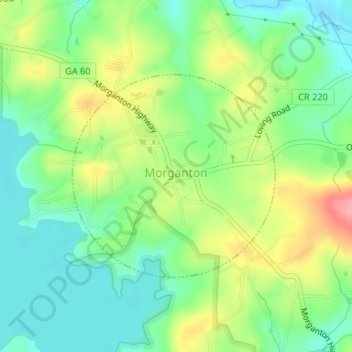
Name: Morganton topographic map, elevation, terrain.

Location: Morganton, Fannin County, Georgia, United States (34.86751 -84.25381 34.88309 -84.23482)

Average elevation: 1,765 ft

Minimum elevation: 1,637 ft

Maximum elevation: 1,975 ft

Fannin County trails, hiking, mountain biking, running and outdoor activities

Other topographic maps

Click on a map to view its topography, its elevation and its terrain.

Cutcane

United States > Georgia > Fannin County

Average elevation: 1,808 ft

Aska

United States > Georgia > Fannin County

Average elevation: 2,064 ft

Ballew Mill

United States > Georgia > Fannin County

Average elevation: 1,827 ft

Davenport Mountain

United States > Georgia > Fannin County

Average elevation: 2,346 ft

Greens Mill

United States > Georgia > Fannin County

Average elevation: 1,857 ft

Colwell

United States > Georgia > Fannin County

Average elevation: 2,067 ft

Higdon

United States > Georgia > Fannin County

Average elevation: 1,952 ft

Cordell Mountain

United States > Georgia > Fannin County

Average elevation: 1,972 ft

Mineral Bluff

United States > Georgia > Fannin County

Average elevation: 1,693 ft

Epworth

United States > Georgia > Fannin County

Average elevation: 1,719 ft

Kyle

United States > Georgia > Fannin County

Average elevation: 1,667 ft

Loving

United States > Georgia > Fannin County > Loving

Average elevation: 1,893 ft