
Largo topographic map
Interactive map
Click on the map to display elevation.
About this map
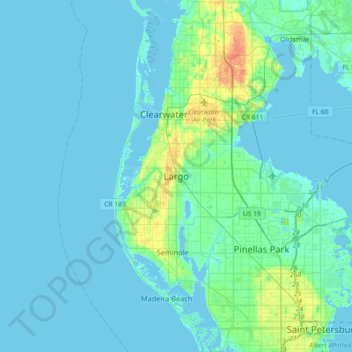
Name: Largo topographic map, elevation, terrain.
Location: Largo, Pinellas County, Florida, 33770-1815, United States (27.74947 -82.94732 28.06947 -82.62732)
Average elevation: 16 ft
Minimum elevation: -7 ft
Maximum elevation: 115 ft
In 2010, Largo's total area was 18.6 square miles (48.1 km2), of which 17.6 square miles (45.6 km2) was land and 0.97 square miles (2.5 km2), or 5.22%, was water. As of 2004, there were 651 acres (2.6 km2) of park lands. The city's lowest elevation is sea level. At its highest, the city's elevation is about 69 feet (21 m). Largo is dotted with a number of lakes, the largest of which is Taylor Lake at 53 acres (210,000 m2). Allen's Creek drains northeast Largo, flowing into Tampa Bay. McKay Creek flows through southwest Largo into the Intracoastal Waterway. The McKay Creek basin is prone to flooding.
Other topographic maps
Click on a map to view its topography, its elevation and its terrain.
Ridgecrest
United States > Florida > Pinellas County > Largo > Baskin
Ridgecrest, Baskin, Largo, Pinellas County, Florida, United States
Average elevation: 59 ft
Taylor Park
United States > Florida > Pinellas County > Largo > Ridgecrest
Taylor Park, Ridgecrest, Largo, Pinellas County, Florida, 33770, United States
Average elevation: 59 ft
Anona
United States > Florida > Pinellas County > Largo > Anona
Anona, Largo, Pinellas County, Florida, 33774, United States
Average elevation: 30 ft
Baskin
United States > Florida > Pinellas County > Largo > Baskin
Baskin, Largo, Pinellas County, Florida, 33778, United States
Average elevation: 46 ft