Geolocate

Anona topographic map

Click on the map to display elevation.

About this map

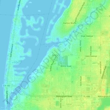
Name: Anona topographic map, elevation, terrain.

Location: Anona, Largo, Pinellas County, Florida, 33774, United States (27.87530 -82.85066 27.91530 -82.81066)

Average elevation: 30 ft

Minimum elevation: -10 ft

Maximum elevation: 79 ft

Pinellas County trails, hiking, mountain biking, running and outdoor activities

Other topographic maps

Click on a map to view its topography, its elevation and its terrain.

Ridgecrest

United States > Florida > Pinellas County > Largo > Ridgecrest

Average elevation: 59 ft

Gear up for your next adventure:

🌄Hiking Binoculars - Compact binoculars for scenic views and trail spotting
🥾Women's Hiking Boots - Top-rated trail boots with ankle support and superior grip
🔭Stargazing Telescopes - Perfect for camping in low-light pollution areas shown on maps
🚪Portable Camp Chair - Foldable chair for comfort at camp
🗺️Topographic Maps - Detailed topo maps for hiking, exploring and outdoor navigation

As an Amazon Associate, this site earns from qualifying purchases at no extra cost to you.