
Baldwin topographic map
Interactive map
Click on the map to display elevation.
About this map
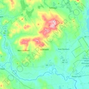
Name: Baldwin topographic map, elevation, terrain.
Location: Baldwin, Cumberland County, Maine, United States (43.78802 -70.80161 43.89018 -70.62679)
Average elevation: 495 ft
Minimum elevation: 217 ft
Maximum elevation: 1,375 ft
Cumberland County trails, hiking, mountain biking, running and outdoor activities
Other topographic maps
Click on a map to view its topography, its elevation and its terrain.
Littlejohn Island
United States > Maine > Cumberland County > Yarmouth > Cousins Island
Average elevation: 16 ft