
Saint Marys topographic map
Interactive map
Click on the map to display elevation.
Saint Marys
According to the United States Census Bureau, the city has a total area of 99.5 square miles (258 km2), of which 99.3 sq mi (257 km2) is land and 0.2 sq mi (0.52 km2) (0.16%) is water. Most of that area is unurbanized, and the large size is due to the city's 1992 merger with surrounding Benzinger Township. The city is at a relatively high elevation of 1,666 ft (508 m) above sea level. The city's territory is bordered by Jones Township to the north, Cameron County to the east, Fox and Jay Townships to the south, and Ridgway Township to the west.
About this map
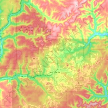
Name: Saint Marys topographic map, elevation, terrain.
Location: Saint Marys, Elk County, Pennsylvania, 15857, United States (41.39049 -78.64852 41.52325 -78.41957)
Average elevation: 1,867 ft
Minimum elevation: 1,332 ft
Maximum elevation: 2,326 ft
Elk County trails, hiking, mountain biking, running and outdoor activities
Other topographic maps
Click on a map to view its topography, its elevation and its terrain.
Four Corners
United States > Pennsylvania > Elk County > Highland Township
Average elevation: 1,814 ft