
Make a donation
Gear up for your next adventure:
As an Amazon Associate, this site earns from qualifying purchases at no extra cost to you.
Lowell topographic map
Click on the map to display elevation.
Make a donation
Gear up for your next adventure:
As an Amazon Associate, this site earns from qualifying purchases at no extra cost to you.
Lowell
Lowell is located at the confluence of the Merrimack and Concord rivers. The Pawtucket Falls, a mile-long set of rapids with a total drop in elevation of 32 feet, ends where the two rivers meet. At the top of the falls is the Pawtucket Dam, designed to turn the upper Merrimack into a millpond, diverted through Lowell's extensive canal system.
Make a donation
Gear up for your next adventure:
As an Amazon Associate, this site earns from qualifying purchases at no extra cost to you.
About this map
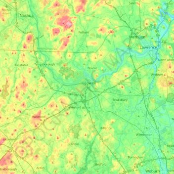
Name: Lowell topographic map, elevation, terrain.
Average elevation: 180 ft
Minimum elevation: 7 ft
Maximum elevation: 564 ft
Middlesex County trails, hiking, mountain biking, running and outdoor activities
Make a donation
Gear up for your next adventure:
As an Amazon Associate, this site earns from qualifying purchases at no extra cost to you.