Viola topographic map
Interactive map
Click on the map to display elevation.
About this map
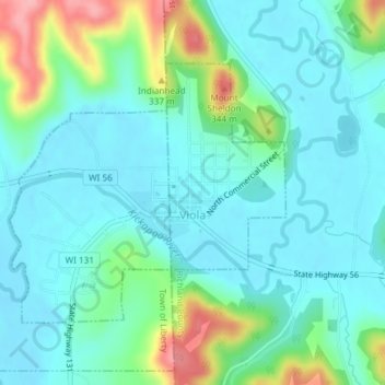
Name: Viola topographic map, elevation, terrain.
Location: Viola, Richland County, Wisconsin, United States (43.49853 -90.68590 43.51673 -90.65914)
Average elevation: 846 ft
Minimum elevation: 748 ft
Maximum elevation: 1,165 ft
Other topographic maps
Click on a map to view its topography, its elevation and its terrain.
Sand Prairie
United States > Wisconsin > Richland County
Sand Prairie, Town of Richwood, Richland County, Wisconsin, 53518, United States
Average elevation: 705 ft
Gotham
United States > Wisconsin > Richland County
Gotham, Town of Buena Vista, Richland County, Wisconsin, 53540, United States
Average elevation: 725 ft
Westport
United States > Wisconsin > Richland County
Westport, Town of Richwood, Richland County, Wisconsin, United States
Average elevation: 748 ft
Town of Eagle
United States > Wisconsin > Richland County
Town of Eagle, Richland County, Wisconsin, 53573, United States
Average elevation: 814 ft
Richland Center
United States > Wisconsin > Richland County
Richland Center, Richland County, Wisconsin, 53581, United States
Average elevation: 866 ft
Gillingham
United States > Wisconsin > Richland County > Gillingham
Gillingham, Town of Marshall, Richland County, Wisconsin, United States
Average elevation: 922 ft