
Auburn topographic map
Interactive map
Click on the map to display elevation.
About this map
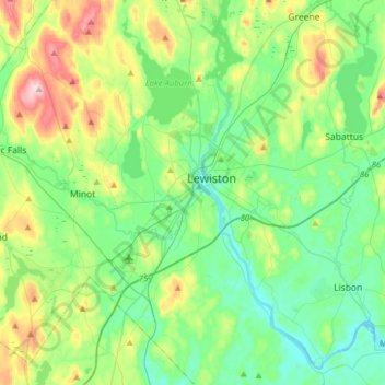
Name: Auburn topographic map, elevation, terrain.
Location: Auburn, Androscoggin County, Maine, 04210, United States (43.97407 -70.31624 44.19907 -70.17090)
Average elevation: 312 ft
Minimum elevation: 92 ft
Maximum elevation: 896 ft
Androscoggin County trails, hiking, mountain biking, running and outdoor activities
Other topographic maps
Click on a map to view its topography, its elevation and its terrain.
East Livermore
United States > Maine > Androscoggin County > Livermore Falls
Average elevation: 364 ft