
Gilead topographic map
Interactive map
Click on the map to display elevation.
About this map
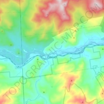
Name: Gilead topographic map, elevation, terrain.
Location: Gilead, Oxford County, Maine, 04217, United States (44.37142 -71.01732 44.42763 -70.86773)
Average elevation: 1,411 ft
Minimum elevation: 646 ft
Maximum elevation: 3,189 ft
Oxford County trails, hiking, mountain biking, running and outdoor activities
Other topographic maps
Click on a map to view its topography, its elevation and its terrain.