
Austin topographic map
Interactive map
Click on the map to display elevation.
About this map
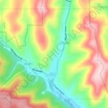
Name: Austin topographic map, elevation, terrain.
Location: Austin, Potter County, Pennsylvania, United States (41.62378 -78.11167 41.65061 -78.06889)
Average elevation: 1,772 ft
Minimum elevation: 1,302 ft
Maximum elevation: 2,283 ft
Potter County trails, hiking, mountain biking, running and outdoor activities
Other topographic maps
Click on a map to view its topography, its elevation and its terrain.
Harmontown
United States > Pennsylvania > Potter County > Genesee Township
Average elevation: 2,142 ft