
Sullivan topographic map
Interactive map
Click on the map to display elevation.
About this map
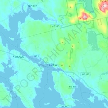
Name: Sullivan topographic map, elevation, terrain.
Location: Sullivan, Hancock County, Maine, 04664, United States (44.48626 -68.25652 44.57783 -68.08490)
Average elevation: 121 ft
Minimum elevation: -3 ft
Maximum elevation: 1,070 ft
Hancock County trails, hiking, mountain biking, running and outdoor activities
Other topographic maps
Click on a map to view its topography, its elevation and its terrain.