
Wahoo topographic map
Interactive map
Click on the map to display elevation.
About this map
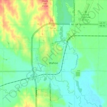
Name: Wahoo topographic map, elevation, terrain.
Location: Wahoo, Saunders County, Nebraska, United States (41.18429 -96.63776 41.24930 -96.58734)
Average elevation: 1,217 ft
Minimum elevation: 1,152 ft
Maximum elevation: 1,352 ft
Other topographic maps
Click on a map to view its topography, its elevation and its terrain.
Cedar Bluffs
United States > Nebraska > Saunders County
Cedar Bluffs, Saunders County, Nebraska, United States
Average elevation: 1,293 ft
Ashland
United States > Nebraska > Saunders County
Ashland, Saunders County, Nebraska, 68003, United States
Average elevation: 1,099 ft
Mead
United States > Nebraska > Saunders County
Mead, Saunders County, Nebraska, 68041, United States
Average elevation: 1,198 ft