
Whitefield topographic map
Interactive map
Click on the map to display elevation.
About this map
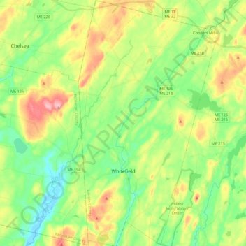
Name: Whitefield topographic map, elevation, terrain.
Location: Whitefield, Lincoln County, Maine, 04353, United States (44.12173 -69.66544 44.27963 -69.54028)
Average elevation: 197 ft
Minimum elevation: -10 ft
Maximum elevation: 531 ft
Lincoln County trails, hiking, mountain biking, running and outdoor activities
Other topographic maps
Click on a map to view its topography, its elevation and its terrain.
Monhegan Island
United States > Maine > Lincoln County > Monhegan Island Plantation > Monhegan
Average elevation: 16 ft
West Boothbay Harbor
United States > Maine > Lincoln County > Boothbay Harbor
Average elevation: 33 ft