
Make a donation
Gear up for your next adventure:
As an Amazon Associate, this site earns from qualifying purchases at no extra cost to you.
Frisco topographic map
Click on the map to display elevation.
Make a donation
Gear up for your next adventure:
As an Amazon Associate, this site earns from qualifying purchases at no extra cost to you.
Frisco
When the Dallas area was being settled by American pioneers, many of the settlers traveled by wagon trains along the Shawnee Trail. This trail became the Preston Trail, and later Preston Road. With all this activity, the community of Lebanon was founded along this trail, and was granted a U.S. post office in 1860. In 1902, a line of the St. Louis-San Francisco Railway was being built through the area, and periodic watering stops were needed along the route for the steam locomotives. The current settlement of Lebanon was on the Preston Ridge, and was too high in elevation, so the watering stop was placed about 4 miles (6 km) to the west on lower ground. A community grew around this train stop. Some Lebanon residents moved their houses to the new community on logs. The new town was originally named Emerson, but the U.S. Postal Service rejected the name as too similar to another community, Emberson, in Lamar County. In 1904, the town's residents chose "Frisco City" in honor of the St. Louis–San Francisco Railway. This name was later shortened to Frisco.
Make a donation
Gear up for your next adventure:
As an Amazon Associate, this site earns from qualifying purchases at no extra cost to you.
About this map
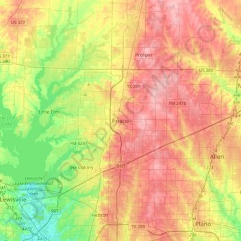
Name: Frisco topographic map, elevation, terrain.
Location: Frisco, Collin County, Texas, 75034, United States (32.99067 -96.98361 33.31067 -96.66361)
Average elevation: 627 ft
Minimum elevation: 436 ft
Maximum elevation: 807 ft
Collin County trails, hiking, mountain biking, running and outdoor activities
Make a donation
Gear up for your next adventure:
As an Amazon Associate, this site earns from qualifying purchases at no extra cost to you.
Other topographic maps
Click on a map to view its topography, its elevation and its terrain.