Scarborough topographic map
Click on the map to display elevation.
Scarborough
According to the United States Census Bureau, the town has a total area of 70.63 square miles (182.93 km2), of which, 47.61 square miles (123.31 km2) is land and 23.02 square miles (59.62 km2) is water. Drained by the Scarborough River, Nonesuch River, Libby River and Spurwink River, the town is situated beside the Gulf of Maine, part of the Atlantic Ocean. The highest point is Beech Ridge, elevation 215 feet (66 m). In early years of Scarborough's settlement bonfires were set on Scottow Hill, elevation 144 feet (44 m), as warnings to the surrounding countryside of approaching danger.
About this map
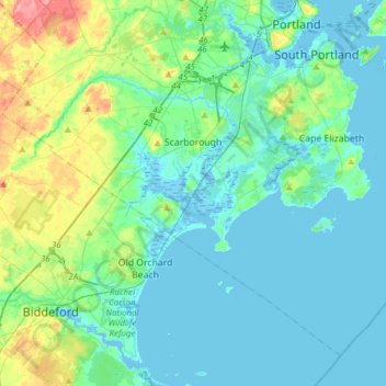
Name: Scarborough topographic map, elevation, terrain.
Location: Scarborough, Cumberland County, Maine, 04074, United States (43.46688 -70.49201 43.65578 -70.18424)
Average elevation: 56 ft
Minimum elevation: -16 ft
Maximum elevation: 285 ft
Cumberland County trails, hiking, mountain biking, running and outdoor activities
Other topographic maps
Click on a map to view its topography, its elevation and its terrain.
Cliff Island
United States > Maine > Cumberland County > Portland > Cliff Island
Average elevation: 3 ft

Great Diamond Island Landing
United States > Maine > Cumberland County > Portland
Average elevation: 13 ft