
Columbus topographic map
Interactive map
Click on the map to display elevation.
About this map
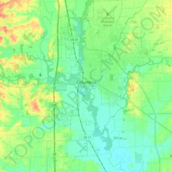
Name: Columbus topographic map, elevation, terrain.
Location: Columbus, Bartholomew County, Indiana, United States (39.12060 -86.00298 39.27485 -85.85090)
Average elevation: 646 ft
Minimum elevation: 594 ft
Maximum elevation: 758 ft
Other topographic maps
Click on a map to view its topography, its elevation and its terrain.
Haw Creek
United States > Indiana > Bartholomew County > Hope
Haw Creek, Hope, Bartholomew County, Indiana, United States
Average elevation: 686 ft
Hartsville
United States > Indiana > Bartholomew County
Hartsville, Bartholomew County, Indiana, United States
Average elevation: 755 ft
Hope
United States > Indiana > Bartholomew County > Hope
Hope, Bartholomew County, Indiana, United States
Average elevation: 725 ft
Corn Brook
United States > Indiana > Bartholomew County > Columbus > Corn Brook
Corn Brook, Columbus, Bartholomew County, Indiana, United States
Average elevation: 643 ft