
Montclair topographic map
Interactive map
Click on the map to display elevation.
About this map
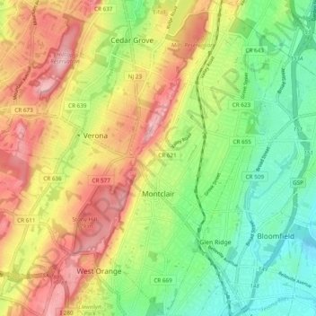
Name: Montclair topographic map, elevation, terrain.
Location: Montclair, Essex County, New Jersey, United States (40.78832 -74.23764 40.86092 -74.18269)
Average elevation: 354 ft
Minimum elevation: 79 ft
Maximum elevation: 692 ft
Essex County trails, hiking, mountain biking, running and outdoor activities
Other topographic maps
Click on a map to view its topography, its elevation and its terrain.
Saint Cloud
United States > New Jersey > Essex County > West Orange > Saint Cloud
Average elevation: 463 ft