
Winter Park topographic map
Interactive map
Click on the map to display elevation.
About this map
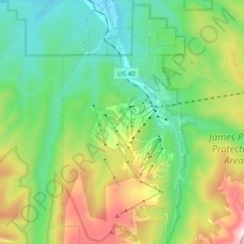
Name: Winter Park topographic map, elevation, terrain.
Location: Winter Park, Grand County, Colorado, United States (39.83223 -105.81202 39.93046 -105.74783)
Average elevation: 10,066 ft
Minimum elevation: 8,704 ft
Maximum elevation: 13,104 ft
Its elevation ranges from approximately 8,700 to 12,060 feet (2,650 to 3,680 m) above sea level, and is considered sub-alpine country. It is snow-covered for about six months a year. Although the town center is at about 9,000 feet (2,700 m) above sea level, Winter Park, using administrative boundaries as a measure, became the highest incorporated town in the United States after the July 2006 annexation of 5,214 acres (21.10 km2) of Winter Park Resort to allow new on-mountain improvements. This claim is disputed since Winter Park has no residences above 9,550 feet (2,910 m), while contiguous residential neighborhoods in Leadville, Colorado, extend to 10,360 feet (3,160 m) and in Alma, Colorado, to 11,680 feet (3,560 m), and Alma's town center is at 10,361 feet (3,158 m).
Other topographic maps
Click on a map to view its topography, its elevation and its terrain.
Morse Mountain
United States > Colorado > Grand County
Morse Mountain, Grand County, Colorado, United States
Average elevation: 9,593 ft
Grand Lake
United States > Colorado > Grand County
Grand Lake, Grand County, Colorado, United States
Average elevation: 8,629 ft
Fraser
United States > Colorado > Grand County
Fraser, Grand County, Colorado, 80442, United States
Average elevation: 8,845 ft
Lake Granby
United States > Colorado > Grand County
Lake Granby, Grand County, Colorado, United States
Average elevation: 8,556 ft
Granby
United States > Colorado > Grand County
Granby, Grand County, Colorado, United States
Average elevation: 8,383 ft
Rabbit Ears Pass
United States > Colorado > Grand County
Rabbit Ears Pass, Grand County, Colorado, United States
Average elevation: 9,357 ft
Bottle Peak
United States > Colorado > Grand County
Bottle Peak, Grand County, Colorado, United States
Average elevation: 10,771 ft
Elk Mountain
United States > Colorado > Grand County
Elk Mountain, Grand County, Colorado, United States
Average elevation: 10,558 ft
Tabernash
United States > Colorado > Grand County
Tabernash, Grand County, Colorado, 80478, United States
Average elevation: 8,504 ft
Kremmling
United States > Colorado > Grand County
Kremmling, Grand County, Colorado, 80459, United States
Average elevation: 7,385 ft
Mount Flora
United States > Colorado > Grand County
Mount Flora, Grand County, Colorado, United States
Average elevation: 12,231 ft
Indian Peaks Wilderness
United States > Colorado > Grand County
Indian Peaks Wilderness, Grand County, Colorado, United States
Average elevation: 10,105 ft