
Gulf Breeze topographic map
Interactive map
Click on the map to display elevation.
About this map
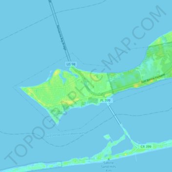
Name: Gulf Breeze topographic map, elevation, terrain.
Location: Gulf Breeze, Santa Rosa County, Florida, United States (30.34079 -87.20695 30.38181 -87.11673)
Average elevation: 3 ft
Minimum elevation: -10 ft
Maximum elevation: 56 ft
Santa Rosa County trails, hiking, mountain biking, running and outdoor activities
Other topographic maps
Click on a map to view its topography, its elevation and its terrain.
Navarre
United States > Florida > Santa Rosa County
Navarre is located at 30°24′04″N 86°51′47″W / 30.401°N 86.863°W / 30.401; -86.863Coordinates: 30°24′04″N 86°51′47″W / 30.401°N 86.863°W / 30.401; -86.863. It is located within a portion of the Florida Panhandle observing the Central Time Zone. Elevation is at an average of 10 feet (3.0 m).
Average elevation: 13 ft