
Make a donation
Gear up for your next adventure:
As an Amazon Associate, this site earns from qualifying purchases at no extra cost to you.
Snowbird topographic map
Click on the map to display elevation.
Make a donation
Gear up for your next adventure:
As an Amazon Associate, this site earns from qualifying purchases at no extra cost to you.
About this map
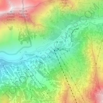
Name: Snowbird topographic map, elevation, terrain.
Location: Snowbird, Salt Lake County, Utah, 85092, United States (40.57075 -111.66730 40.59075 -111.64730)
Average elevation: 9,055 ft
Minimum elevation: 7,759 ft
Maximum elevation: 11,070 ft
Salt Lake County trails, hiking, mountain biking, running and outdoor activities
Make a donation
Gear up for your next adventure:
As an Amazon Associate, this site earns from qualifying purchases at no extra cost to you.
Other topographic maps
Click on a map to view its topography, its elevation and its terrain.
Kearns
United States > Utah > Salt Lake County
Kearns, in the mid to late twentieth century, saw rapid growth on the former airbase. The old streets and foundations of buildings built by the military were used as a template for the town, and homes sprang up quickly as Kearns was becoming the first suburb in Salt Lake County. By the 1970s and into the…
Average elevation: 4,619 ft
Granite Park
United States > Utah > Salt Lake County > Sandy > Granite Crest
Average elevation: 5,033 ft
Make a donation
Gear up for your next adventure:
As an Amazon Associate, this site earns from qualifying purchases at no extra cost to you.