
Make a donation
Gear up for your next adventure:
As an Amazon Associate, this site earns from qualifying purchases at no extra cost to you.
Whidbey Island topographic map
Click on the map to display elevation.
Make a donation
Gear up for your next adventure:
As an Amazon Associate, this site earns from qualifying purchases at no extra cost to you.
Whidbey Island
Whidbey Island features a diverse topography characterized by a mix of rolling hills, lush forests, and dramatic coastal cliffs. The island stretches approximately 55 miles in length and up to 12 miles wide, rising to elevations of about 500 feet at its highest point. Its terrain includes expansive farmland and rugged shorelines, interspersed with sandy beaches and rocky outcrops along the Puget Sound. Deception Pass, a notable feature, consists of steep cliffs and a narrow strait that offers stunning views and is bridged by the iconic Deception Pass Bridge. The varied landscape supports a rich ecosystem, making it a haven for outdoor activities like hiking, kayaking, and wildlife observation.
Make a donation
Gear up for your next adventure:
As an Amazon Associate, this site earns from qualifying purchases at no extra cost to you.
About this map
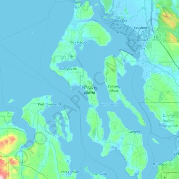
Name: Whidbey Island topographic map, elevation, terrain.
Location: Whidbey Island, Island County, Washington, United States (47.90492 -122.76999 48.41132 -122.34936)
Average elevation: 148 ft
Minimum elevation: -13 ft
Maximum elevation: 3,258 ft
Island County trails, hiking, mountain biking, running and outdoor activities
Make a donation
Gear up for your next adventure:
As an Amazon Associate, this site earns from qualifying purchases at no extra cost to you.
Other topographic maps
Click on a map to view its topography, its elevation and its terrain.