
Grand Turk topographic map
Interactive map
Click on the map to display elevation.
About this map
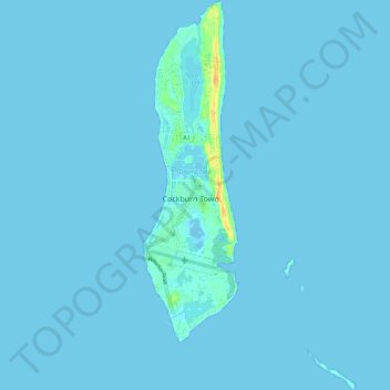
Name: Grand Turk topographic map, elevation, terrain.
Location: Grand Turk, Turks and Caicos Islands (21.40970 -71.15363 21.51350 -71.09261)
Average elevation: 3 ft
Minimum elevation: -16 ft
Maximum elevation: 89 ft
Other topographic maps
Click on a map to view its topography, its elevation and its terrain.