Geolocate

Queens County topographic map

Click on the map to display elevation.

Queens County

Many of the village street grids of Queens had only worded names, some were numbered according to local numbering schemes, and some had a mix of words and numbers. In the early 1920s, a "Philadelphia Plan" was instituted to overlay one numbered system upon the whole borough. The Topographical Bureau, Borough of Queens, worked out the details. Subway stations were only partly renamed, and some, including those along the IRT Flushing Line (7 and <7>​ trains), now share dual names after the original street names. In 2012, some numbered streets in the Douglaston Hill Historic District were renamed to their original names, with 43rd Avenue becoming Pine Street.

Wikipedia (CC-BY-SA 3.0)

About this map

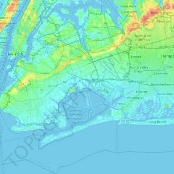
Name: Queens County topographic map, elevation, terrain.

Location: Queens County, New York, United States (40.49212 -74.04378 40.81214 -73.70023)

Average elevation: 36 ft

Minimum elevation: -26 ft

Maximum elevation: 358 ft

New York trails, hiking, mountain biking, running and outdoor activities

Other topographic maps

Click on a map to view its topography, its elevation and its terrain.

Todt Hill

United States > New York > New York

Average elevation: 246 ft

Snug Harbor Cultural Center and Botanical Garden

United States > New York > New York

Building C, also known as the Administration Building, was completed in 1833 and is Lafever's oldest surviving work. As of 2020, building C houses part of the Newhouse Center for Contemporary Art. The building consists of two stories, a raised basement, and an attic; it is rectangular in plan with a gable…

Average elevation: 66 ft

Todt Hill

United States > New York > New York

Average elevation: 164 ft

Saw Mill Creek

United States > New York > New York

Average elevation: 10 ft

Spuyten Duyvil Hill

United States > New York > New York

Average elevation: 69 ft

Vault Hill

United States > New York > New York

Average elevation: 135 ft

Flushing Meadows-Corona Park

United States > New York > New York

Around 1907, contractor Michael Degnon, whose firm constructed the Williamsburg Bridge, the Cape Cod Canal, and the Steinway subway tunnel (used by today's 7 and <7>​ trains), purchased large tracts of marsh near Flushing Creek. At the time, the land was considered "all but worthless". Degnon envisioned…

Average elevation: 49 ft

Fort Greene Park

United States > New York > New York

Average elevation: 56 ft

Lenox Hill

United States > New York > New York

Average elevation: 66 ft

Flushing Bay

United States > New York > New York

Average elevation: 13 ft

Gravesend Bay

United States > New York > New York

Average elevation: 7 ft

Hunter Island

United States > New York > New York

Average elevation: 138 ft

Lookout Hill

United States > New York > New York

Average elevation: 105 ft

Veterans Park

United States > New York > New York

Average elevation: 30 ft

Kaiser Park

United States > New York > New York

Average elevation: 7 ft

Twin Island

United States > New York > New York

Average elevation: 135 ft

Emerson Hill

United States > New York > New York

Average elevation: 174 ft

Sylvan Water

United States > New York > New York

Average elevation: 82 ft

Jackie Robinson Park

United States > New York > New York

Average elevation: 72 ft

Lawrence Point

United States > New York > New York

Average elevation: 13 ft

Willets Point

United States > New York > New York

Average elevation: 7 ft

Gear up for your next adventure:

🛡️Insect Repellent - Protection against bugs during outdoor activities
🎒Trekking Poles - Sturdy poles for balance and stability on rough terrain
🎁Geography Themed Gifts - Unique gift ideas for map lovers and geography enthusiasts
🧤Hiking Gloves - Protective gloves for rugged trails
🛠️Backpacking Tool Kit - Essential toolkit for outdoor repairs

As an Amazon Associate, this site earns from qualifying purchases at no extra cost to you.