
Pittsboro topographic map
Interactive map
Click on the map to display elevation.
About this map
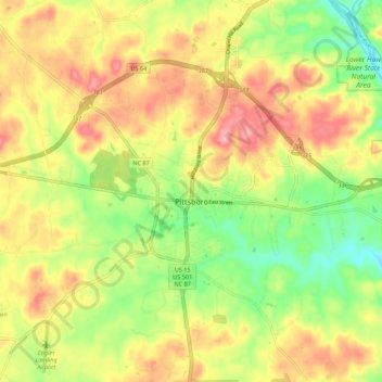
Name: Pittsboro topographic map, elevation, terrain.
Location: Pittsboro, Chatham County, North Carolina, United States (35.67814 -79.20125 35.76698 -79.13531)
Average elevation: 443 ft
Minimum elevation: 266 ft
Maximum elevation: 607 ft
Chatham County trails, hiking, mountain biking, running and outdoor activities
Other topographic maps
Click on a map to view its topography, its elevation and its terrain.
Governors Club
United States > North Carolina > Chatham County > Governors Club
Average elevation: 351 ft
Town of Pittsboro
United States > North Carolina > Chatham County > Town of Pittsboro
Average elevation: 404 ft