
Eureka topographic map
Interactive map
Click on the map to display elevation.
Eureka
Eureka, located along Humboldt Bay in Northern California, has a diverse and varied topography. The city itself is situated at relatively low elevations, with the bay’s narrow point serving as a key feature in the landscape. Its average elevation is around 50 feet (15 meters), and the terrain gently rises toward the southeast, where it begins to encroach into the surrounding forests, including second-growth redwood and Douglas-fir woods. While most of Eureka sits at modest elevations, the surrounding area features more varied terrain, with higher ridges and hills rising to over 2,800 feet (850 meters). The coastal location provides a transition from the bay's flatlands to the rugged foothills and mountains that lie further inland.
About this map
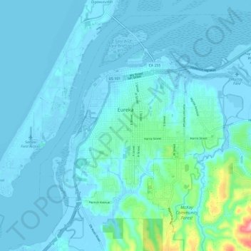
Name: Eureka topographic map, elevation, terrain.
Location: Eureka, Humboldt County, California, United States (40.74535 -124.20815 40.82476 -124.08966)
Average elevation: 59 ft
Minimum elevation: -20 ft
Maximum elevation: 614 ft
Humboldt County trails, hiking, mountain biking, running and outdoor activities
Other topographic maps
Click on a map to view its topography, its elevation and its terrain.
McKinleyville
United States > California > Humboldt County
McKinleyville (formerly Minorsville) is a census-designated place (CDP) in Humboldt County, California McKinleyville is located 5.25 miles (8.4 km) north of Arcata, at an elevation of 141 feet (43 m). The population was 15,177 at the 2010 census, up from 13,599 at the time of the 2000 census.
Average elevation: 161 ft
Eureka
United States > California > Humboldt County > Eureka
The city marina is on one of three islands at a narrow point on the 13-mile-long (21 km) bay and increases in elevation slightly as it spreads north, south, and especially to the east. The city gently encroaches at least two miles (3.2 km) eastward into primarily Redwood and Douglas-fir second growth forests.…
Average elevation: 328 ft
Trinidad
United States > California > Humboldt County
Trinidad (Spanish for "Trinity"; Yurok: Chuerey) is a seaside city in Humboldt County, located on the Pacific Ocean 8 miles (13 km) north of the Arcata-Eureka Airport and 15 miles (24 km) north of the college town of Arcata. Trinidad is noted for its coastline with ten public beaches and offshore rocks, part…
Average elevation: 125 ft
Hydesville
United States > California > Humboldt County
Hydesville is a census-designated place (CDP) in Humboldt County, California, United States. Hydesville is located 4.5 miles (7.2 km) southeast of Fortuna, at an elevation of 364 feet (111 m). The population was 1,237 at the 2010 census, up from 1,209 at the 2000 census.
Average elevation: 531 ft
McKinleyville
United States > California > Humboldt County
McKinleyville (formerly Minorsville) is a census-designated place (CDP) in Humboldt County, California. McKinleyville is located 5.25 miles (8.4 km) north of Arcata, at an elevation of 141 feet (43 m). The population was 15,177 at the 2010 census, up from 13,599 at the time of the 2000 census.
Average elevation: 161 ft
Lone Star Junction
United States > California > Humboldt County > Lone Star Junction
Average elevation: 2,014 ft
Orick
United States > California > Humboldt County
Orick (formerly, Arekw, Orekw, and Oreq, Yurok: 'O'rekw ) is a census-designated place situated on the banks of the Redwood Creek in Humboldt County, California. It is located 43 miles (69 km) north of Eureka, at an elevation of 26 feet (8 m). The population was 357 at the 2010 census.
Average elevation: 410 ft
Blue Lake
United States > California > Humboldt County
Blue Lake (formerly, Scottsville) is a city in Humboldt County, California, United States. Blue Lake is located on the Mad River in a deep valley, 16 miles (26 km) northeast of Eureka, at an elevation of 131 feet (40 m). Its population is 1,208 as of the 2020 census, down from 1,253 from the 2010 census.
Average elevation: 243 ft